keel
keel Basque
 Bulgarian
 Catalan
 Czech
Czech Danish
 Dutch
Dutch English
 Finnish
 French
 Galician
 German
 Hungarian
 Chinese (traditional)
 Italian
 Latvian
 Lithuanian
 Polish
 Portuguese
 Romanian
 Russian
 Spanish
 Swedish
 Turkish
 Ukrainian
Uudised
(Uudised on RSS väljundina saadaval siin)
25.9.2015
micro.windguru.cz, the ultra lite version of Windguru.
The "micro" site was mainly made for offshore sailors who can only access internet using very bandwidth limited satellite or radio connections. Forecasts here are as small as possible, text only. You can view forecasts for any spot registered on Windguru or for any latitude / longitude you choose (PRO users only).
18.9.2015
WRF 9 km resolution! forecasts for East Asia. (Ainult PRO kasutajatele)
Kaetud ala kaart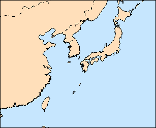
14.1.2015
NOAA/NCEP made a major GFS model upgrade. GFS forecasts now cover all globe with 27 km horizontal resolution. We also extended the forecast horizont to 10 days.
This is a big upgrade that affect not only windguru, but all the sites that rely on GFS (most of weather sites on the internet ;-), if you were used to make decisions based on GFS you should reconsider the way how you interpret the forecasts for your spot now, it may take a while to get used to the new forecasts.
Hope this is a good step for better forecasts all around the world!
30.11.2013
Prices for Windguru PRO are now in EUR, you can also choose to pay in USD or CZK (price will recalculate according to latest official exchange rate). The shortest subscription is now 1 month.
10.9.2013
By the end of July NOAA changed the output of their NWW3 models, since then many people complained about exaggerated wave forecasts of the coarse (1.25 x 1.0 degree resolution) data which we had inside GFS forecast. To eliminate this problem NWW3 50 km is now the default that displays inside GFS forecasts, this dataset seems to be more accurate. (Registered users can configure their preferences in settings.)
7.8.2013
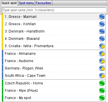
Quick spot select. Now we have a more comfortable spot selection tool. This little input field in the main spot menu and other places throughout the website is made to pick a spot as fast as possible. Bye bye long and complicated menus...
|
1. Last 5 used spots (sorted by last use, yellow) 2. Your favourite spots (icon with a star) 3. Your custom spots (green) You can use [up] and [down] arrow keys to select spot and confirm with [enter] key, or pick s spot by mouse. First item is always pre-selected - just hit [enter] to confirm. As you start typing the spots get filtered to shorten the list. |
|
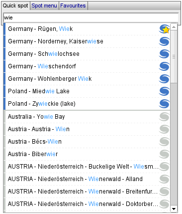
Once you enter 3 or more characters it will search all the spots available on windguru and update the list accordingly. Different kind of spots are marked by different colors and little windguru icons for easier navigation. If found, spots are sorted by importance and then alphabetically. Your favourite and custom spots come first, followed by "official" windguru spots (blue icons) and then custom spots entered by other users (grey icons). We keep the older spot menu and favorite menus of course, but this new quick spot tool is now the default. Hope you like it! :) |
6.4.2013
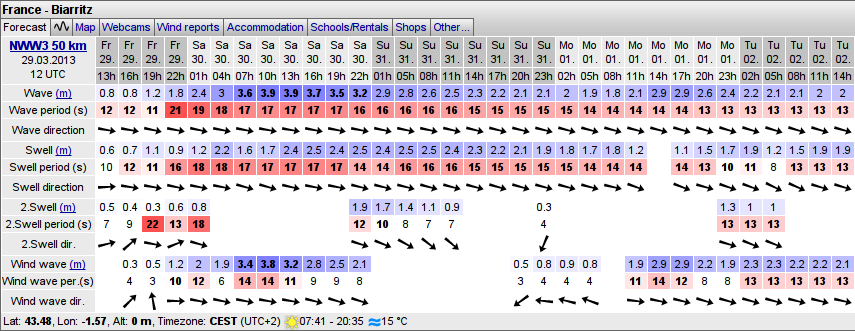
NWW3 50 km resolution wave model forecasts Especially surfers might be interested in this new addon... As you might already know the wave forecasts on windguru are powered by NWW3 model from NOAA and we only used their data with 1 latitude x 1.25 longitude degree resolution. Maybe you still remember... long time ago we tried to switch to the higher (0.5 x 0.5 degree) resolution model from NOAA, but after several complaints about aaccuracy of the new forecasts we reverted back. But... advantage of the higher resolution NWW3 model is that it not only offers the basic parameters (wave height, direction and period) but also distinguish different components: primary swell, secondary swell and wind waves. The coarse resolution NWW3 data do not have this.
Now we have both. By default we show the new 50 km NWW3 model as a separate table under the GFS forecast and the GFS forecast still includes the older NWW3 100 km resolution data, same as before. If you have other preference simply go to settings -> preferences where you can configure how to display waves (registered users only). You can choose which data to include inside GFS forecasts and which wave models to display as separate tables.
If you have some custom spots and want to have wave forecasts for them, you should now visit the settings section to check their wave forecast configuration.
15.3.2013
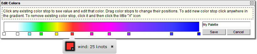
Custom colors in forecasts. The default colors in the forecasts were selected very carefully and we believe this is the best for average windsurfer or kiter. In case you have other preference, you now have an option, feel free to edit colors anyhow according to your personal taste. See settings -> colors. (ainult registreeritud kasutajatele)
24.1.2013
WRF 3 km resolution! forecasts for Gibraltar/Tarifa. Forecasts are for next 48 hours and update 4 times per day. (Ainult PRO kasutajatele)
Kaetud ala kaart
22.1.2013
WRF 9 km forecasts for Canaries and Egypt now include wind and temperature profile plots too (see 2D tab on forecasts).
12.1.2013
WRF 12 km for Argentina now updates 4 times per day and include wind and temperature profile plots (see 2D tab on forecasts).

|

|
26.11.2012
Official Windguru app for Android. It's quite simple and very simliar to our mobile site at touch.windguru.cz. The main purpose of this app is to get easily to your windguru forecast on your phone or tablet. It does not have many features (at least yet) but should do what we need the most: to view the forecast in the format we are all used to :-)
Main features:- Classic windguru forecast tables
- Bandwith friendly. The app minimize downloads and should work even on slow internet connections.
- Supports offline use. When offline, the app can still display previously loaded forecasts.
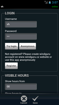
The plan is to release official apps for all major platforms and all these apps should look and work same or at least very similiar.
Please note that some Windguru apps already exist for several platforms (Android, iPhone, Windows Mobile, Windows Phone) - see the Help section. These apps are made by external partners and still are and will be supported by Windguru as alternatives.
19.11.2012
Some minor updates:
- Email alerts now support pressure as another parameter.
- WRF archives now also include precipitation and clouds.
- Started process of unifiyng the appearance of the forecast maps, previously the WRF maps were generated by different software and looked a little different than maps we made for GFS, NAM etc., we want to make all the maps look same. At the moment we changed maps for WRF 9 km model for Europe and WRF 3 km for Czech republic. The other WRF models should follow soon. For Europe we now have a little different detailed maps then before and also added 4 maps that show larger areas at once (NW, NE, SW and SE of Europe), should be useful to get a better overview of the forecast.
13.11.2012
WRF 9 km resolution! forecasts for South Africa. (Ainult PRO kasutajatele)
Kaetud ala kaart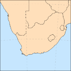
18.1.2011
A little update of the Email alerts. Alerts now support conditions for wind gusts, and waves (NWW3 model).
9.1.2012
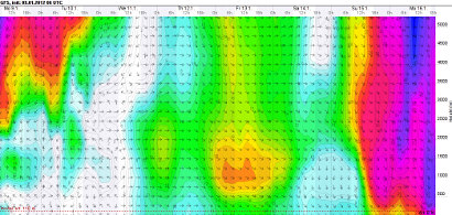
Wind and temperature profile plots. Now you can see what wind and temperature is forecasted in different altitudes. Mouse over the "2D" tab on the forecast to select the profile. Same as the graphs introduced recently, the plots are drawn by the browser, SVG graphics support is required (all browsers except Internet Explorer 8 or below).

1.12.2011
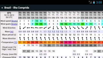
Graphical version of the forecast. Now you can also see the forecasts as graphs, simply click the tab with graph icon at any forecast table.
Since the beginning of this site, the core of Windguru was the forecast displayed as colorful table with a lot of numbers. I think it will stay like this in future too because despite one can consider it a bit oldschool, the table shows a lot of info with high detail on a small space and still looks clear and uncluttered. But why not to offer alternative display option? Forecast graph offers another view, more eye candy :-) and some people will prefer it.
If you like to have the graphical view as your default, you can set it using the "options tab" on the main page.
Important notice: Your browser must support SVG graphics in order to display the graphical forecast. All good browsers (Chrome, Firefox, Opera, Safari, IE 9) are OK, but if you have Internet Explorer 8 or older it will not work, please switch to better browser if this is your case.
The positive thing is that all the graphs are not plain images that require additional data download, instead they are drawn by your browser, so it is also bandwith friendly for those with slower connections.
Graph example
What you see below is the first version of the graphical forecast (probably not final, we expect to fine-tune it over time).
There are two main sections of the graph, the upper part is dedicated to the most important = wind, it scales depending on how much wind is predicted, if strong wind is forecasted it is bigger, if there is not much wind it becomes smaller.
The bottom part shows the "less important" parameters like temperature, clouds, precipitation, pressure and humidity - all drawn into one section to save space.The cloud cover display is a little special so it needs a little more explanation: low clouds are the dark grey area that is drawn from bottom of the graph, high clouds are light grey drawn from the top of this graph section and middle clouds (medium grey) are drawn from the center both up and downwards. If any of these fill all the area then it means 100% cloud cover for given cloud layer. Because all the cloud layers are semi-transparent if there is a lot of clouds in all layers the whole cloud graph turns almost black indicating a lot of clouds, the darker it is the more clouds are forecasted and you can still see how much each layer participate.
Right now the units for wind speed and temperature are taken from the classic table forecast, if you want to switch them temporarily, go back to the normal forecast, change units to what you prefer and then open the graph tab again, it will redraw with selected units.
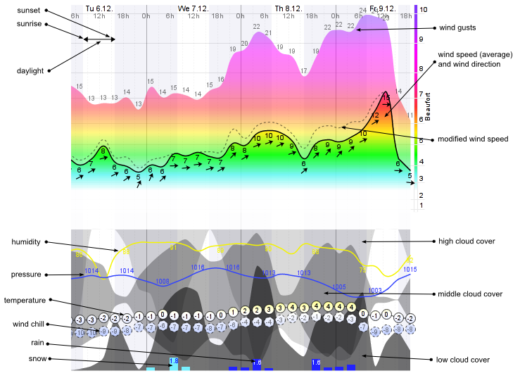
Future plans are to use the graphical display for visualizing temperature profile and wind in higher levels. We also plan to allow users to customize graph appearance because not only wind addicted people watch Windguru and they probably have other preferences.
If you have an opinion or idea about the new graphs feel free to send some feedback. Thanks!
20.11.2011
NAM 3 km resolution model forecasts for Hawaii! Updates are 4 times per day. See on kõigile kasutajatele tasuta.
Kaetud ala kaart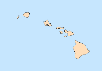
3.9.2011
New version of webmaster forecasts available! This is the recommended method of adding Windguru to your site now. It's very easy... simply copy and paste piece of HTML code to your site and you are done. Get the forecast code here!
20.7.2011
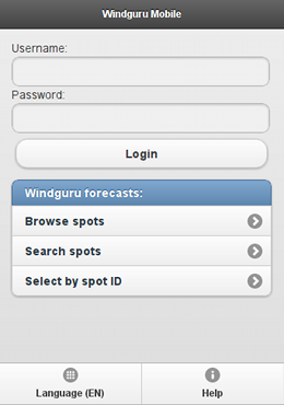
Windguru Mobile (beta). Windguru mobile version is optimized for touchscreen devices - smartphones or tablets. The purpose of this site is to get easily to your Windguru forecast using the touch screen. Windguru mobiiliversioon peaks töötama enamike tänapäevaste mobiilibrauseritega kuid siiski pidage seda beetaversiooniks. Ilmneda võivad vead, palun vabandust võimalike probleemide pärast.
Try it at: http://touch.windguru.cz
16.5.2011
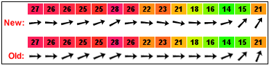
Wind / wave direction now displayed with higher precision. This is a tiny update which you will hardly notice but can be useful... Till now windguru only displayed 16 different arrows for direction (22.5 degree precision), now it can display it exactly without this limit. Your browser must support SVG graphics to see the difference (all better browsers do support it - Chrome, Firefox, Opera, Safari... if you use Internet Explorer then you need the current version 9, older IE versions will not work)
14.5.2011
HRW 5 km resolution model forecasts for part of Caribbean. Covers area around Dominican republic and Puerto Rico. See kõrge resolutsiooniga mudel uueneb kaks korda päevas ning pakub ühetunnise sammuga ennustust kuni 48 tunniks ette. See on kõigile kasutajatele tasuta
Kaetud ala kaart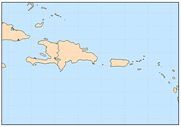
17.2.2011
Windguru for Windows Phone 7. Available from Windows Phone Marketplace, for FREE! The application is developed by Justin Drerup (fanetic.com).
21.1.2011
Email alerts! Do not want to miss great forecast for your spot? Setup windguru email alerts and windguru will send you email whenever the forecast meet the desired conditions. (Alerts based on WRF models are only available to PRO users)
18.11.2010
WRF 3 km resolution! forecasts for Czech republic. Such a high resolution requires a lot of computing so the domain can't cover a large area, forecasts are for next 48 hours and update 4 times per day. (Ainult PRO kasutajatele)
Kaetud ala kaart
17.11.2010
WRF 9 km domain for Europe extended. We have moved the domain slightly towards north and extended northwards and eastwards so that it now covers whole British Isles, Denmark, south of Sweeden, bigger part of Baltic sea and Latvia..
Kaetud ala kaart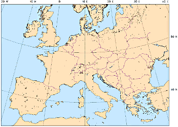
15.11.2010
Windguru for Windows Mobile 6.5. The application is developed by Justin Drerup (fanetic.com).
It's FREE.
29.7.2010
Added wind gusts to GFS model forecasts.
22.7.2010
Windguru in latvian! The latvian version is maintained by Reinis Pļaviņš, Zane Kreslina & Igor Krumin
15.05.2010
WRF 12 km resolution model forecasts for Argentina. (Also covers Uruguay, most of Chile, part of Paraguay and the very south of Brazil). This high-resolution model updates twice per day and offers forecast for 78 hours with 1 hour step. Please note this is still a preview only, the final version should update 4 times per day and the coverage might be a little different. (Ainult PRO kasutajatele)
Kaetud ala kaart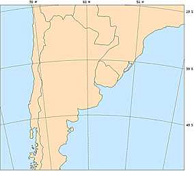
10.5.2010
Added sea surface temperatures. Data come from NOAA Real-Time Global Sea Surface Temperature analysis (RTG_SST_HR dataset), the source is satellite data and also buoy and ship observations.

11.4.2010
Ennustuskaardid HRW 4 km ennustussammuga mudelilt Ameerika Ühendriikidele. (Ainult PRO kasutajatele)
9.4.2010
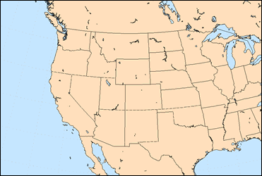
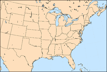
HRW 4 km võrgusammuga mudeliennustused Ameerika Ühendriikide jaoks! Need kõrge resolutsiooniga mudeliennustused tulevad NOAA/NWS'ilt (USA ilmateenistus) ning neid jooksutab WRF mudel, mis on sarnane Hawaii HRW ennustustele. NOAA kutsub seda HRW'ks (ingl k. High Resolution Window) nii, et kasutame sama nime. Nad jooksutavad kahte erinevat ennustusala, üks katab USA idaosa keskosa ning uuendab kaks korda päevas (me kutsume seda HRWe) ning teine USA lääneosa keskosa ning uuendab korra päevas(HRWw). Mõlemad pakuvad ennustust 48 tunniks ühetunnise sammuga. See on kõigile kasutajatele tasuta
Kaetud ala kaart:
HRWw (US west/central) |
HRWe (US east/central) |
 |
 |
4.4.2010
Pärast paljusid kaebusi laineennustuste uuenduse kohta 27. märtsil naaseme eelmise madalama resolutsiooniga NWW3 andmestiku juurde. Hiljem saame lisada kõrgema resolutsiooniga andmed uuesti, kuid valikulise seadena kasutajatele kes soovivad seda testida.
27.3.2010
Lainetuse ennustused põhinevad nüüd NWW3 andmestikul, mille võrgusamm on 50 km. Siiani kasutasime madala resolutsiooniga andmeid (1x1,25 kraadi), mis vastab enam kui 100-kilomeetrisele sammule. See uuendus peaks muutma lainetuse ennustused natuke paremaks. Kui teil on sisestatud kohti, millel on lainetuse ennustus sisse lülitatud, lülitage need sisse oma seadetes, eriti kui sisestasite lainetuse jaoks alternatiivsed koordinaadid.
19.1.2010
Windguru Androidile. Programmi saab alla laadida ja paigaldada Android Market'ist. See on TASUTA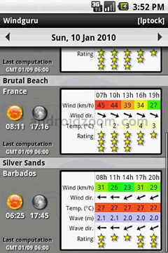
1.1.2010
Tuulekülm on nüüd saadaval valikulise parameetrina ennustustabelites (registreeritud kasutajad saavad selle sisse lülitada seadetes)
7.12.2009
GFS, NAM & HRW ennustuskaardid (Ainult PRO kasutajatele). Kaardid katavad mitut piirkonda üle maailma, näidates tuule kiirust, temperatuuri, sademeid ja pilvkatet.
24.11.2009
HRW 5 km võrgusammuga mudeliennustused Hawaii jaoks! See kõrge resolutsiooniga mudel uueneb kaks korda päevas ning pakub ühetunnise sammuga ennustust kuni 48 tunniks ette. See on kõigile kasutajatele tasuta
Kaetud ala kaart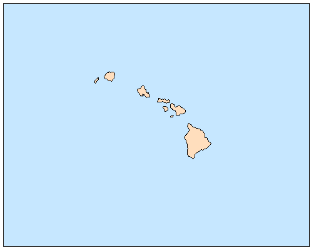
6.11.2009
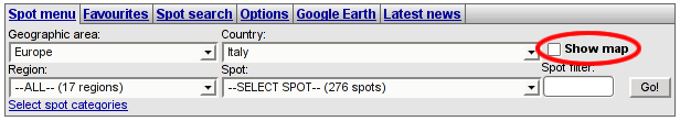
Nüüd saate valida kohti Google kaardilt. See uus funktsioon peaks Teid eriti aitama kui otsite ennustust konkreetse piirkonna jaoks, kuid te ei tea, kust te peaksite pikas kohtade menüüs otsima. Te saate näidata kaarti klikkides "näita kaarti" märkeruutu kohamenüü lähedal (vaadake allpool olevat pilti). Kaart laeb alati kohad, mida näete "vali koht" menüüs.
Näiteks: kui valite Itaalia, näitab kohamenüü kõiki kohti Itaalias ning lisab need ka kaardile. Kui soovite näha kõiki kohti Euroopas, siis valige riigi valikumenüüs KÕIK. Te saate vaadata isegi KÕIKI kohti maailmas, valides KÕIK kontinendid ning seejärel KÕIK riigid. Ärge unustage, et see laeb väga palju kohti ning teeb arvuti aeglaseks! Ma soovitaksin kaarti kasutada soovitatud veebilehitsejatega. Internet Explorer ei ole soovitatud kuna see on teistega võrreldes väga aeglane.
If there are more spots too close to each other they are grouped in the map, click the group icon to zoom in and show more detail.
30.10.2009
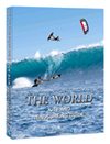 Me oleme lisanud üle 1000 koha ametlikku nimekirja. See oli võimalik tänu meie koostööle Stoked Publications'iga, kes andis just välja nende uue väljaande WORLD KITE AND WINDSURFING GUIDE. See on esimene kõikehõlmav teejuht lohesurfi ja purjelauaga sõidu regioonidesse maailmas. Ta tutvustab peaaegu sadat regiooni üheksas kontinentaalses peatükis ning sisaldab üle 1200 maailma parima koha. Ta on illustreeritud 700 foto ja detailsega kaardiga igast regioonist. Lisaks: detailsed selgitused tuulte, lainetuse ning ilmastiku olude kohta aasta jooksul. Teejuht pakub samuti autentset reisiinfot ning oluliselt tähtsaid juhiseid, mida oodata igast regioonist ning mis on edukaks reisiks hädavajalik. Lisaks, kuid mitte kindlasti kõige vähemaks, sisaldab raamat kohalikke poodide, tootjate, koolide, tehnika rendi, majutuse, restoranide, autode rentijate kontaktandmeid ja teisi insider'i juhiseid. Äärmiselt soovitatud!
Kõik teejuhis mainitud kohad on nüüd Windguru ennustustega kaetud.
2.8.2009
WRF 9 km võrgusammuga ennustused Egiptuse jaoks! Uus WRF ennustuala katab Punase mere põhjaosa ning populaarseid kohti Egiptuses, Iisraelis, Liibanonis ja Küprosest lõunas.
Kaetud ala kaart: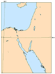
6.7.2009
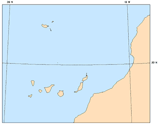
WRF 9 km võrgusammuga mudeliennustused Kanaari saartele! Uus 9 km sammuga ennustusala katab ka Madeirat ning osaliselt Maroko Atlandi rannikut.
Kaetud ala kaart: