valoda
 Basque
 Bulgarian
 Catalan
 Czech
Czech Danish
 Dutch
Dutch English
 Estonian
 Finnish
 French
 Galician
 German
 Hungarian
 Chinese (traditional)
 Italian
 Lithuanian
 Polish
 Portuguese
 Romanian
 Russian
 Spanish
 Swedish
 Turkish
 Ukrainian
Ziņas
(Jaunumi RSS barotnē pieejami šeit)
25.9.2015
micro.windguru.cz, the ultra lite version of Windguru.
The "micro" site was mainly made for offshore sailors who can only access internet using very bandwidth limited satellite or radio connections. Forecasts here are as small as possible, text only. You can view forecasts for any spot registered on Windguru or for any latitude / longitude you choose (PRO users only).
18.9.2015
WRF 9 km resolution! forecasts for East Asia. (tikai PRO lietotājiem)
Nosegto apgabalu karte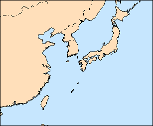
14.1.2015
NOAA/NCEP made a major GFS model upgrade. GFS forecasts now cover all globe with 27 km horizontal resolution. We also extended the forecast horizont to 10 days.
This is a big upgrade that affect not only windguru, but all the sites that rely on GFS (most of weather sites on the internet ;-), if you were used to make decisions based on GFS you should reconsider the way how you interpret the forecasts for your spot now, it may take a while to get used to the new forecasts.
Hope this is a good step for better forecasts all around the world!
30.11.2013
Prices for Windguru PRO are now in EUR, you can also choose to pay in USD or CZK (price will recalculate according to latest official exchange rate). The shortest subscription is now 1 month.
10.9.2013
By the end of July NOAA changed the output of their NWW3 models, since then many people complained about exaggerated wave forecasts of the coarse (1.25 x 1.0 degree resolution) data which we had inside GFS forecast. To eliminate this problem NWW3 50 km is now the default that displays inside GFS forecasts, this dataset seems to be more accurate. (Registered users can configure their preferences in settings.)
7.8.2013
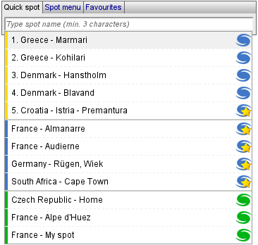
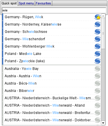
Quick spot select. Now we have a more comfortable spot selection tool. This little input field in the main spot menu and other places throughout the website is made to pick a spot as fast as possible. Bye bye long and complicated menus...
|
1. Last 5 used spots (sorted by last use, yellow) 2. Your favourite spots (icon with a star) 3. Your custom spots (green) You can use [up] and [down] arrow keys to select spot and confirm with [enter] key, or pick s spot by mouse. First item is always pre-selected - just hit [enter] to confirm. As you start typing the spots get filtered to shorten the list. |
|
Once you enter 3 or more characters it will search all the spots available on windguru and update the list accordingly. Different kind of spots are marked by different colors and little windguru icons for easier navigation. If found, spots are sorted by importance and then alphabetically. Your favourite and custom spots come first, followed by "official" windguru spots (blue icons) and then custom spots entered by other users (grey icons). We keep the older spot menu and favorite menus of course, but this new quick spot tool is now the default. Hope you like it! :) |
6.4.2013
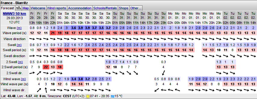
NWW3 50 km resolution wave model forecasts Especially surfers might be interested in this new addon... As you might already know the wave forecasts on windguru are powered by NWW3 model from NOAA and we only used their data with 1 latitude x 1.25 longitude degree resolution. Maybe you still remember... long time ago we tried to switch to the higher (0.5 x 0.5 degree) resolution model from NOAA, but after several complaints about aaccuracy of the new forecasts we reverted back. But... advantage of the higher resolution NWW3 model is that it not only offers the basic parameters (wave height, direction and period) but also distinguish different components: primary swell, secondary swell and wind waves. The coarse resolution NWW3 data do not have this.
Now we have both. By default we show the new 50 km NWW3 model as a separate table under the GFS forecast and the GFS forecast still includes the older NWW3 100 km resolution data, same as before. If you have other preference simply go to settings -> preferences where you can configure how to display waves (registered users only). You can choose which data to include inside GFS forecasts and which wave models to display as separate tables.
If you have some custom spots and want to have wave forecasts for them, you should now visit the settings section to check their wave forecast configuration.
15.3.2013
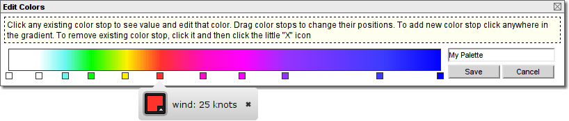
Custom colors in forecasts. The default colors in the forecasts were selected very carefully and we believe this is the best for average windsurfer or kiter. In case you have other preference, you now have an option, feel free to edit colors anyhow according to your personal taste. See settings -> colors. (tikai reģistrētiem lietotājiem)
24.1.2013
WRF 3 km resolution! forecasts for Gibraltar/Tarifa. Forecasts are for next 48 hours and update 4 times per day. (tikai PRO lietotājiem)
Nosegto apgabalu karte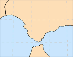
22.1.2013
WRF 9 km forecasts for Canaries and Egypt now include wind and temperature profile plots too (see 2D tab on forecasts).
12.1.2013
WRF 12 km for Argentina now updates 4 times per day and include wind and temperature profile plots (see 2D tab on forecasts).

|

|
26.11.2012
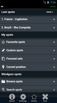
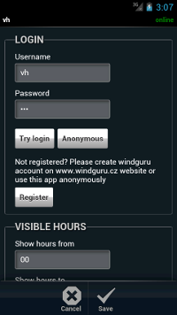
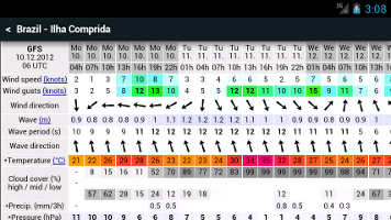
Official Windguru app for Android. It's quite simple and very simliar to our mobile site at touch.windguru.cz. The main purpose of this app is to get easily to your windguru forecast on your phone or tablet. It does not have many features (at least yet) but should do what we need the most: to view the forecast in the format we are all used to :-)
Main features:- Classic windguru forecast tables
- Bandwith friendly. The app minimize downloads and should work even on slow internet connections.
- Supports offline use. When offline, the app can still display previously loaded forecasts.
The plan is to release official apps for all major platforms and all these apps should look and work same or at least very similiar.
Please note that some Windguru apps already exist for several platforms (Android, iPhone, Windows Mobile, Windows Phone) - see the Help section. These apps are made by external partners and still are and will be supported by Windguru as alternatives.
19.11.2012
Some minor updates:
- Email alerts now support pressure as another parameter.
- WRF archives now also include precipitation and clouds.
- Started process of unifiyng the appearance of the forecast maps, previously the WRF maps were generated by different software and looked a little different than maps we made for GFS, NAM etc., we want to make all the maps look same. At the moment we changed maps for WRF 9 km model for Europe and WRF 3 km for Czech republic. The other WRF models should follow soon. For Europe we now have a little different detailed maps then before and also added 4 maps that show larger areas at once (NW, NE, SW and SE of Europe), should be useful to get a better overview of the forecast.
13.11.2012
WRF 9 km resolution! forecasts for South Africa. (tikai PRO lietotājiem)
Nosegto apgabalu karte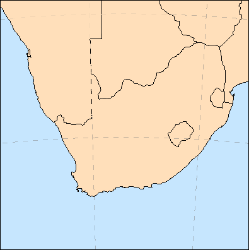
18.1.2011
A little update of the Email alerts. Alerts now support conditions for wind gusts, and waves (NWW3 model).
9.1.2012
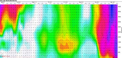
Wind and temperature profile plots. Now you can see what wind and temperature is forecasted in different altitudes. Mouse over the "2D" tab on the forecast to select the profile. Same as the graphs introduced recently, the plots are drawn by the browser, SVG graphics support is required (all browsers except Internet Explorer 8 or below).

1.12.2011
Graphical version of the forecast. Now you can also see the forecasts as graphs, simply click the tab with graph icon at any forecast table.
Since the beginning of this site, the core of Windguru was the forecast displayed as colorful table with a lot of numbers. I think it will stay like this in future too because despite one can consider it a bit oldschool, the table shows a lot of info with high detail on a small space and still looks clear and uncluttered. But why not to offer alternative display option? Forecast graph offers another view, more eye candy :-) and some people will prefer it.
If you like to have the graphical view as your default, you can set it using the "options tab" on the main page.
Important notice: Your browser must support SVG graphics in order to display the graphical forecast. All good browsers (Chrome, Firefox, Opera, Safari, IE 9) are OK, but if you have Internet Explorer 8 or older it will not work, please switch to better browser if this is your case.
The positive thing is that all the graphs are not plain images that require additional data download, instead they are drawn by your browser, so it is also bandwith friendly for those with slower connections.
Graph example
What you see below is the first version of the graphical forecast (probably not final, we expect to fine-tune it over time).
There are two main sections of the graph, the upper part is dedicated to the most important = wind, it scales depending on how much wind is predicted, if strong wind is forecasted it is bigger, if there is not much wind it becomes smaller.
The bottom part shows the "less important" parameters like temperature, clouds, precipitation, pressure and humidity - all drawn into one section to save space.The cloud cover display is a little special so it needs a little more explanation: low clouds are the dark grey area that is drawn from bottom of the graph, high clouds are light grey drawn from the top of this graph section and middle clouds (medium grey) are drawn from the center both up and downwards. If any of these fill all the area then it means 100% cloud cover for given cloud layer. Because all the cloud layers are semi-transparent if there is a lot of clouds in all layers the whole cloud graph turns almost black indicating a lot of clouds, the darker it is the more clouds are forecasted and you can still see how much each layer participate.
Right now the units for wind speed and temperature are taken from the classic table forecast, if you want to switch them temporarily, go back to the normal forecast, change units to what you prefer and then open the graph tab again, it will redraw with selected units.
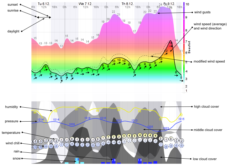
Future plans are to use the graphical display for visualizing temperature profile and wind in higher levels. We also plan to allow users to customize graph appearance because not only wind addicted people watch Windguru and they probably have other preferences.
If you have an opinion or idea about the new graphs feel free to send some feedback. Thanks!
20.11.2011
NAM 3 km resolution model forecasts for Hawaii! Updates are 4 times per day. Tas ir par brīvu visiem lietotājiem.
Nosegto apgabalu karte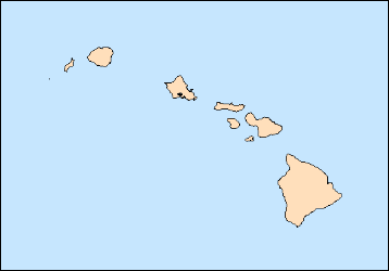
3.9.2011
New version of webmaster forecasts available! This is the recommended method of adding Windguru to your site now. It's very easy... simply copy and paste piece of HTML code to your site and you are done. Get the forecast code here!
20.7.2011
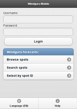
Windguru Mobile (beta). Windguru mobile version is optimized for touchscreen devices - smartphones or tablets. The purpose of this site is to get easily to your Windguru forecast using the touch screen. Windguru Mobile should work with most modern mobile browsers but please still consider it beta version only. Some bugs can appear, please excuse possible troubles.
Try it at: http://touch.windguru.cz
16.5.2011
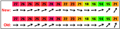
Wind / wave direction now displayed with higher precision. This is a tiny update which you will hardly notice but can be useful... Till now windguru only displayed 16 different arrows for direction (22.5 degree precision), now it can display it exactly without this limit. Your browser must support SVG graphics to see the difference (all better browsers do support it - Chrome, Firefox, Opera, Safari... if you use Internet Explorer then you need the current version 9, older IE versions will not work)
14.5.2011
HRW 5 km resolution model forecasts for part of Caribbean. Covers area around Dominican republic and Puerto Rico. Šis augstās izšķirtspējas modelis atjaunojas 2 reizes dienā un piedāvā prognozes 48 stundām ar 1 stundas soli. Tas ir par brīvu visiem lietotājiem
Nosegto apgabalu karte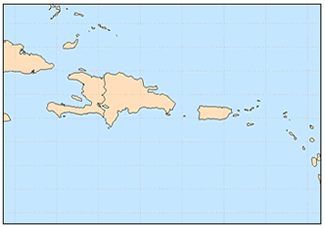
17.2.2011
Windguru for Windows Phone 7. Available from Windows Phone Marketplace, for FREE! The application is developed by Justin Drerup (fanetic.com).
21.1.2011
Email alerts! Do not want to miss great forecast for your spot? Setup windguru email alerts and windguru will send you email whenever the forecast meet the desired conditions. (Alerts based on WRF models are only available to PRO users)
18.11.2010
WRF 3 km resolution! forecasts for Czech republic. Such a high resolution requires a lot of computing so the domain can't cover a large area, forecasts are for next 48 hours and update 4 times per day. (tikai PRO lietotājiem)
Nosegto apgabalu karte
17.11.2010
WRF 9 km domain for Europe extended. We have moved the domain slightly towards north and extended northwards and eastwards so that it now covers whole British Isles, Denmark, south of Sweeden, bigger part of Baltic sea and Latvia..
Nosegto apgabalu karte
15.11.2010
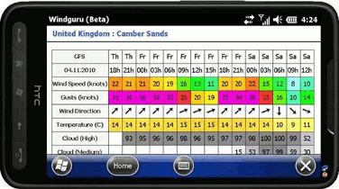
Windguru for Windows Mobile 6.5. The application is developed by Justin Drerup (fanetic.com).
It's FREE.
29.7.2010
GFS modeļa prognozēm tika pievienotas vēja brāzmas.
22.7.2010
Windguru latviešu valodā! Latviešu valodas versiju ir sagatavojis Reinis Pļaviņš, Zane Kreslina & Igor Krumin
15.05.2010
WRF 12 km izšķirtspējas modeļa prognozes Argentīnai. (Kā arī pārklāj Urugvaju, lielāko daļu Čīles, daļu no Paragvajas un Brazīlijas pašus dienvidus). Augstās izšķirtspējas modelis atjaunojas 2 reizes dienā un piedāvā prognozes 78 stundām ar 1 stundas soli. Lūdzu ievērojiet, ka šis pagaidām ir tikai piemērs, galīgajai versijai vajadzētu atjaunoties 4 reizes dienā un parklājums varētu mazliet atšķirties. (tikai PRO lietotājiem)
Nosegto apgabalu karte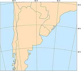
10.5.2010
Pievienotas jūras virsmas temperatūras. Dati tiek iegūti no NOAA Real-Time Global Sea Surface Temperature analysis (RTG_SST_HR dataset),avoti ir satelīta dati un boju un kuģu novērojumi.

11.4.2010
Prognožu mapes no HRW 4 km modeļa ASV. (tikai PRO lietotājiem)
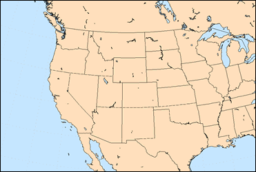
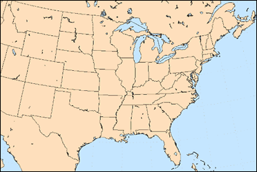
9.4.2010
HRW 4 km izšķirtspējas modeļa prognozes ASV! Šīs augstās izšķirtspējas modeļa prognozes tiek iegūtas no NOAA/NWS (ASV laikapstākļu dienests) un viņi lieto WRF modelis, līdzīgs kā HRW prognozēm Havaju salām. NOAA to dēvē par HRW (High Resolution Window), tāpēc arī mēs lietosim šo pašu apzīmējumu. Tas darbojas 2 dažādās teritorijās, viena pārklāj ASV centrālo austrumu daļu un atjaunojas 2 reizes dienā (mēs to apzīmējam kā HRWe), un otra ASV centrālo rietumu daļu un atjaunojas 1 reizi dienā (HRWw). Abas nodrošina prognozi 48 stundām ar 1 stundas soli. Tas ir par brīvu visiem lietotājiem
Nosegto apgabalu karte:
HRWw (US west/central) |
HRWe (US east/central) |
 |
 |
4.4.2010
Pēc vairākām sūdzībām par viļņu prognožu uzlabojumu 27. martā, mēs atgriežamies atpakaļ pie zemākas izšķirtspējas NWW3 datu kopuma. Vēlāk mēs varam pievienot augstākas izšķirtspējas datus, bet tikai kā papildu iespēju lietotājiem, kuri vēlas to testēt.
27.3.2010
Tagad viļņu prognozes tiek veidotas ar NWW3 datu kopu ar 50 km izšķirtspēju. Līdz šim mēs lietojām mazākas izšķirtspējas datus (1 x 1.25 grāds), kas atbilda mazliet virs 100 km. Šim jauninājumam vajadzētu padarīt viļņu prognozes mazliet labākas. Ja Jums ir kādām pašizveidotajām vietām ieslēgtas viļņu prognozes, lūdzu pārbaudiet tās Jūsu iestatījumos, it īpaši tad, ja Jūs esat ievadījis koordinātes viļņiem.
19.1.2010
Windguru Android. Aplikāciju var lejuplādēt un instalēt no Android Market. Tas ir PAR BRĪVU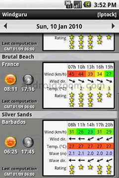
1.1.2010
Vēja temperatūra ir tagad pieejams kā izvēles parametrs prognožu tabulās (reģistrētie lietotāji to var izvēlēties iestatījumos).
7.12.2009
GFS, NAM & HRW prognožu kartes (tikai PRO lietotājiem). Kartes pārklāj vairākus pasaules apgabalus, uzrādot vēja ātrumu, temperatūru, nokrišņus un mākoņu daudzumu.
24.11.2009
HRW 5 km izšķirtspējas modeļa prognozes Havaju salām! Šis augstās izšķirtspējas modelis atjaunojas 2 reizes dienā un piedāvā prognozes 48 stundām ar 1 stundas soli. Tas ir par brīvu visiem lietotājiem
Nosegto apgabalu karte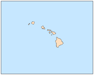
6.11.2009
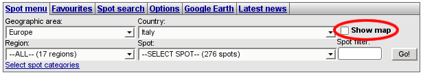
Tagad Jūs varat izvēlēties vietas no google kartes. Šī jaunā iespēja Jums palīdzēs īpaši tad, kad Jūs meklējat prognozes kādai konkrētai vietai, bet nezināt, kur lai to atrod lielajā vietu izvēlnē. Jūs varat ieraudzīt karti, nospiežot "rādīt karti" checkbox netālu no vietu izvēlnes (skatīt attēlu zemāk). Karte vienmēr ielādēs vietas, kuras Jūs varat redzēt "izvēlēties vietu" izvēlnē.
Piemēram: izvēlieties Itāliju, vietu izvēlne piepildīsies ar visām vietām Itālijā un tās arī ielādēsies un parādīsies kartē. Ja Jūs vēlaties redzēt visas vietas Eiropā, tad izvēlieties VISS valstu izvēlnē. Jūs pat varat redzēt pilnīgi VISAS pieejamās vietas, izvēloties VISUS kontinentus un tad VISAS valstis, bet atcerieties - tas ielādēs daudzas vietas un būs lēni.... Es ieteiktu izmantot karti ar ieteicamajām pārlūkprogrammām. Internet Explorer nav ieteicams, jo tas ir ļoti lēns salīdzinājumā ar citām.
If there are more spots too close to each other they are grouped in the map, click the group icon to zoom in and show more detail.
30.10.2009
 Mēs esam pievienojuši vairāk kā 1000 jaunu vietu oficiālajam sarakstam. Tas bija iespējams pateicoties mūsu sadarbībai ar Stoked Publications, kas tikko laida klajā savu jauno WORLD KITE AND WINDSURFING GUIDE. Pirmais visaptverošais kaitošanas un vindsērfinga pasaules vietu ceļvedis. Tajā var iepazīties ar gandrīz 100 reģioniem 9 kontinentu nodaļās, ietverot vairāk kā 1200 pasaules labāko vietu. Tas ilustrē 700 attēlus un katra reģiona detalizētas kartes. Plus: padziļinātus visa gada vēju, viļņu un laikapstākļu paskaidrojumus. Ceļvedis piedāvā arī autentisku ceļošanas informāciju ar svarīgiem padomiem, ko sagaidīt konkrētos reģionos un kas ir svarīgi veiksmīgam ceļojumam. Visbeidzot grāmata satur arī vietējo veikalu, skolu un inventāra nomu kontaktinformāciju, kā arī apmešanās vietu, restorānu, automašīnu īres un citus ieteikumus. Ļoti ieteicams!
Visām ceļvedī pieminētajām vietām tagad ir pieejamas arī Windguru prognozes.
2.8.2009
WRF 9 km izšķirtspējas modeļa prognozes Ēģiptei! Jaunais WRF laukums pārklāj Sarkanās jūras ziemeļus ar populārām vietām Ēģiptē, arī Izraēlu, Libānu un Kipras dienvidus.
Nosegto apgabalu karte: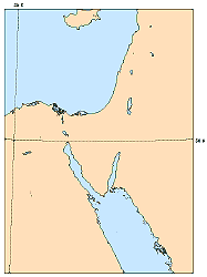
6.7.2009
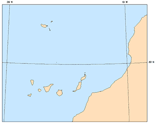
WRF 9 km izšķirtspējas modeļa prognozes Kanāriju salām! Jaunais 9 km laukums pārklāj arī Madeiru un daļu no Atlantijas okeāna Marokas piekrasti
Nosegto apgabalu karte: